


Every year, the Open Geospatial Consortium (OGC) organizes the Testbed, a series of activities where industry leaders get together to try out the latest technologies affecting the Geospatial industry.
At this year’s Testbed 16, Hexagon participated in the Full Motion Video (FMV) activity. The focus was on moving object detection and interoperability.
Standardization
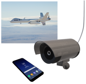 Full Motion Imagery is essentially video data that may have been taken from a phone, a drone, CCTV, or any other device. Those devices will often have embedded processors allowing a certain amount of direct analysis, the result of which can be sent as video metadata.
Standardization of this metadata a challenge; adhering to the standards put forward by the Motion Imagery Standards Board (MISB) is the best way to accomplish the task. Specifically, MISB 0903 and MISB 0601 allow video files to transport all the metadata that will ever be needed for tracking moving objects through video.
Video Analysis
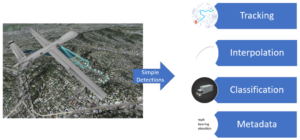 While drones and other devices have growing analytic capabilities, their processing power is still limited because they run in real time and lack access to large databases. In practice, FMV metadata usually contains only the location of each moving object per frame.
From simple detections, we explored how to complete the overall picture. The result is a tracking algorithm that joins detections together into tracks, disambiguates complex situations, and smooths the jitter caused by inaccurate measurements from the original devices.
With access to large terrain elevation and road network databases, the accuracy of the detections is programmatically improved. Finally, Machine Learning models are used to classify the tracked objects.
Interoperability
The MISB standards are very complete, but they are also designed to send data in the most efficient way possible through binary packages that are complex to work with. We tested several interoperability formats that make it easy to disseminate information.
- OGC Moving Features is an ideal format for developers because it is easy to decode and readable by humans.
- The SensorThings API defines Web services that perfectly accommodate this type of information.
- WebVMT is another format equivalent to OGC Moving Features.
Exploiting the Data
 We couldn’t have done all this work without putting together a demonstration.
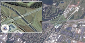
The location of a drone and the drapped video feed are displayed in 3D and in real time. At the same time, the application is dynamically applying the post-processing (tracking, classification, interpolation…) and displaying the result.
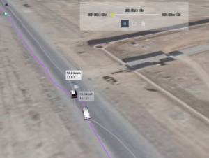 When an entire video stream or video file has been processed, the result can be saved to one of the interoperability formats. The demo reads those and allows a user to explore the historical data together with other geospatial data sources for complete situational awareness.
OGC will continuing to work on this topic in Testbed 17. The goal will be to have a complete use case with servers and clients managing large amounts of video data to give emergency response teams situational awareness over very large areas, such as forests and nature reserves.
Learn more about Hexagon’s solutions that provide situational awareness and location intelligence.
