In order to communicate, we must speak the same language. This holds true for computers and IT systems as much as it does for people. Standards allow different programs to communicate with each other. Without them, data remains locked up, its use limited to a small set of applications. But standards liberate information, allowing applications can talk to each other so work can get done efficiently. In the geospatial industry, the Open Geospatial Consortium (OGC) defines the standards for us. OGC Certification means that our products rigorously comply with the standards.
The OGC is an international non-profit organization committed to making quality open standards for the global geospatial community. The OGC makes these standards through a consensus process among companies, government agencies, and universities. These freely available standards help the geospatial industry improve sharing of the world’s geospatial data. These standards help companies make complex spatial information and services compatible with all kinds of applications.
WebGIS Products Receive OGC Certification
We tie all the Hexagon Geospatial WebGIS products to the OGC standards. We even develop some products along with the OGC specification.
While GeoMedia WebMap has been OGC compliant since 2009, both Geospatial SDI and Geospatial Portal have their roots in implementing the OGC standards baseline and “geo-enabling” the Web.
The server products, such as Geospatial SDI and GeoMedia WebMap provide the OGC compliant services and the Geospatial Portal, which is a web application, acts as a connector and consumer for all the OGC compliant services.
Each release must all be re-evaluated for certification. Thus, GeoMedia WebMap 2016 in all tiers (Essentials, Advantage, Professional) and Geospatial SDI 2016 have followed the rigorous tests using a set of OGC test suites that check for interoperability with WFS, WMS and CSW web services.
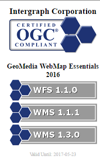
GeoMedia WebMap 2016 Essentials, Advantage and Professional successfully passed the following OGC Certification Compliance Tests:
- Web Feature Service (WFS) 1.1.0
- Web Map Service (WMS) 1.1.1
- Web Map Service (WMS) 1.3.0
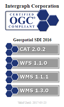
Geospatial SDI 2016 successfully passed the following OGC Compliance Tests:
- Catalog Service (CSW) 2.0.2
- Web Feature Service (WFS) 1.1.0
- Web Map Service (WMS) 1.1.1
- Web Map Service (WMS) 1.3.0