


Authors
- Isla Duporge, PhD Researcher, Wildlife Conservation Research Unit, Dept. of Zoology, University of Oxford
- Dr. Olga Isupova, Postdoctoral Research Associate, ML Research Group, University of Oxford
- Dr. Steven Reece, Dept. Research Fellow in the Pattern Analysis, ML Research Group, University of Oxford
While poaching is a well-known issue affecting numerous animal species, many people are not aware that humans and elephants often struggle over natural resources in other ways. For example, the human population in Africa is rapidly increasing and, as a result, more elephant habitats are being repurposed for agricultural production and human settlement.
For this reason, human residents use several techniques to deter elephants from entering their cropland and inhabited areas. These techniques include chili fences/bombs, bee fences, and technological solutions designed as early warning systems for communities.
To plan long-term, sustainable solutions, it is necessary to have accurate data on elephant numbers and their geographical range to be able to identify high-risk areas.
Various methods are used to conduct elephant surveys, including line transect surveys, dung and track counts, aerial surveys, and camera trap surveys. However, one under-explored area of research is the use of high-resolution satellite imagery to monitor herds.
To help better protect elephants from the human/wildlife conflict over land use, we have developed a monitoring solution using remote sensing and machine learning which can be used to identify herds. The solution ultimately assists both people and wildlife so they can better share the Earth.
Employing Satellite Data for Wildlife Detection
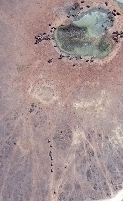
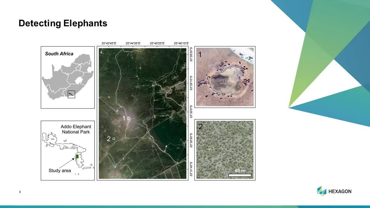
As part of our DigitalGlobe Foundation imagery grant, we used DigitalGlobe’s WorldView-3 and WorldView-4 satellites to access multispectral imagery at 30 cm resolution after pan-sharpening. The Elephants Without Borders non-profit organization also contributed GPS tracking collars to elephant herds in the Kavango Zambezi Transfrontier Conservation Area in Sub-Saharan Africa. Without this location data, it would take hours to screen images at full zoom to detect herds; a fully-grown bull elephant shows up in less than 15 pixels on a WorldView-3 or WorldView-4 image.
Processing the images took many weeks. For this step, we decided to use ERDAS IMAGINE. Firstly, Hexagon’s ERDAS IMAGINE remote sensing solution was necessary for identifying the area of interest (AOI) where a concentration of elephants could be identified and to mosaic the strips of both the panchromatic and multispectral images together to cover this area.
The second step was to perform a pan-sharpening process utilizing both images. The panchromatic (black and white) bands are at finer resolution (31 cm) compared with the multispectral bands (1.24 cm). The Red, Green, Blue, and Near-Infrared bands were used during this process.
After the transformation, we were left with an image showing the AOI at 31 cm utilizing 4 bands. ERDAS IMAGINE was the ideal option for processing the images as it contains built-in functions programmed specifically for WorldView-3 and WorldView-4 images, ordering the bands correctly for these satellites. Additionally, the images were automatically interpolated, with pyramids built using the nearest neighbor resampling option, providing a clean image to use.
Developing an Automated Solution
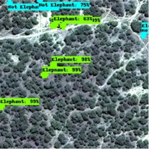
With all of the valuable resources at our disposal, we developed a convolutional neural network (CNN), an algorithm that automates the detection of herds in satellite images. To do this, the GPS data was cross-referenced with image coordinates from the WorldView-3 and WorldView-4 imagery library. This provided the algorithm with exact examples of what elephants look like from space.
Additionally, training data was collected from Addo Elephant National Park in South Africa, where there is a high concentration of elephants in a relatively small area. After labeling satellite images by drawing bounding boxes around individual elephants and non-elephant objects (e.g. trees) in the landscape, machine learning (ML) was applied via a CNN to teach the machine the difference.
Increased Accuracy with Artificial Intelligence and Machine Learning
Once the algorithm has been fully tested, it will be used to detect wild populations in images without using GPS-collar data. This project reveals great potential for artificial intelligence (AI) and machine learning, especially with respect to approaching novel wildlife challenges.
There are already a number of CNNs that are more accurate than human detection in some challenging image classification and object detection areas. With enough training data, CNNs have the ability to learn complex, distinctive features of objects in short time periods and assign objects to predefined categories with the same or even higher accuracy compared with human detection.
Results from this study will be published later this year so other researchers can build on the findings. This technique is expected to dramatically improve the future of monitoring elephant populations, particularly as the resolution of satellite imagery increases and the AI/ML field advances. Developing a close to real-time monitoring technique will allow scientists to track herds more accurately and efficiently, enabling more effective conservation planning and management.
—
An Update on the Team’s Work
Duporge and her team travelled the continent of Africa during 2020. They were able to track over a thousand CNNs and learned that the model outperforms humans in heterogeneous areas. With no previous training data, the team tested the machine learning model in Kenya and for the first time, they were able to detect an elephant calf. Duporge is very excited about her finding and is thanking to Hexagon and other partners for helping her make her dreams a reality.
Watch the video below for more details on the study.
To learn more about machine learning, watch Hexagon’s Introduction to Machine Learning Tech Talk video.
About The Author: Isla Duporge
Duporge is a Mistler Graduate Scholar working toward a PhD (DPhil) at the Wildlife Conservation Research Unit, Department of Zoology at the University of Oxford. She has a MSc degree in Environmental Science and Remote Sensing from Uppsala University and SLU in Sweden and The University of Life Sciences in Vienna, Austria. Her PhD research is concerned with developing methodologies to monitor wildlife using geospatial and remote sensing tools to increase count precision, collection efficiency, and cost effectiveness compared with conventional ground-based sampling methods.
Additionally, Duporge is testing the accuracy of using a long-range fixed wing drone (WingtraOne) to conduct a wildlife survey in Southern Zambia.
The National Geographic Committee for Research and Exploration is supporting her DPhil Fieldwork as an ‘Early Career Explorer.’
