


Soil erosion can lead to numerous negative outcomes, such as soil degradation and removal, resulting in land deprivation and lowering of agricultural productivity.
Fran Domazetović, a PhD student at the University of Zadar in Croatia, is a DigitalGlobe grant recipient who set out to better understand the soil erosion mechanism and intensity with the aid of technology from Hexagon’s Geospatial division.
His research, called, “Multiresolution modelling of soil erosion through the use of geospatial technologies,” has been focused on Pag Island, located within Northern Dalmatian archipelago, Croatia. He hopes that his research will be the basis for planning soil erosion limitation and mitigation measures that could prevent further endangerment of valuable soil sediments and grasslands on Pag Island.
Gathering Soil Erosion Data from Pag Island
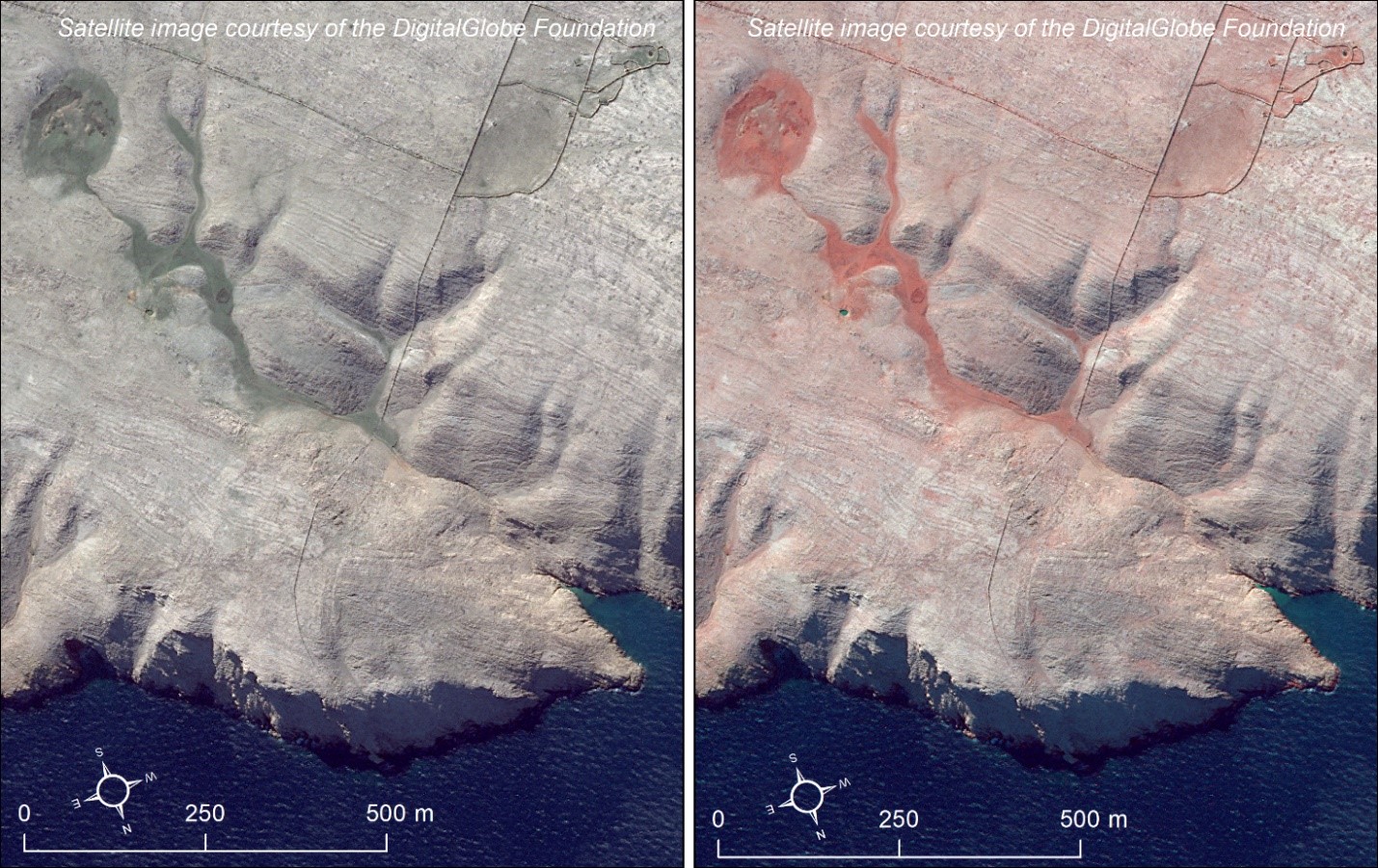
Research focusing on Pag Island is particularly valuable due to the island’s unique bare, karstic landscape and specific scarce vegetation cover. Harsh climatic conditions and various anthropogenic influences (e.g. intensive grazing and deforestation) have led to the occurrence of intensive soil erosion that threatens remaining soil sediments. Soil sediments are the basis of the Mediterranean grassland environment, which is part of Natura 2000, a network of protected core breeding and resting sites for rare and threatened species in the European Union.
Within his PhD program, Fran studies soil erosion on a macro, meso, and micro level. Within the macro level, Fran uses very high resolution (VHR) Worldview-2 multispectral imagery and digital surface models (DSM) for detection and mapping of remaining soil sediments and main erosion hotspots within Pag Island.
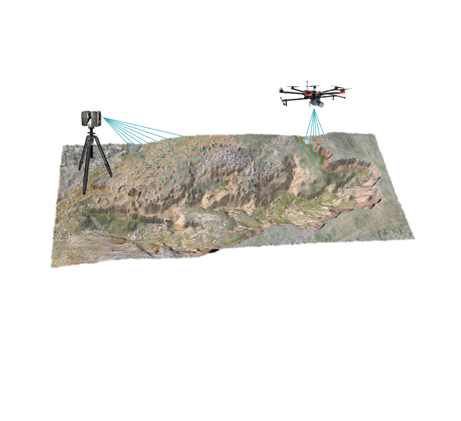
Within the meso level, his research is focused on two-year monitoring of soil erosion intensity within an 80m long, active gully. For this purpose, LiDAR and UAV photogrammetry are used for periodic creation of centimeter resolution 3D gully models.
The micro level studies the influence of specific climate change-related intensive rain events on the occurrence and intensity of erosion. Detailed in-situ collected meteorological data are correlated to the millimeter precision models of 1 x 1m test sites within Gully Santiš, and these test sites are scanned periodically with a handheld 3D scanner.
In addition to other geospatial software, Fran used strategic solutions from Hexagon in his research. These included the ERDAS IMAGINE remote sensing software, IMAGINE Photogrammetry photogrammetric processing tool, and Stereo Analyst for ArcGIS extension (which provides stereo visualization to feature collection and vector editing tools).
ERDAS IMAGINE was used for processing, radiometric correction, supervised classification, and detection of remaining soil sediments. The ERDAS IMAGINE MosaicPro workstation was used for mosaicking and color balancing different WV-2 multispectral images that covered the study area. Furthermore, IMAGINE Photogrammetry was used for creation of DSMs from provided stereo-pairs.
The Impact of Fran’s Work
Fran has stated that there is still more work to do in his research, but he has made great strides.
Recently, he presented his work in Athens, Greece, at the Regional Conference on Geomorphology, discussing how his studies have made it possible to detect soil erosion and quantify related spatio-temporal changes. He has also expressed that the (previous) DigitalGlobe/Hexagon partnership contributed largely to the progress of his research.
Take a look at similar stories from Hexagon Geospatial Education students on our website.
