


Tracking the Increasing Number of Oil Palms with ERDAS IMAGINE’s Machine Learning and Object Detection
The oil palm is a valuable economic crop and a basic source of income for farmers in Southeast Asia, West Africa, and Central America. The plant produces palm oil, which is used as cooking oil and exported for use in commercial food and personal care products. Palm oil can also be converted into biofuel. Oil palms produce more than 10 times the oil per unit area when compared to soybeans, rapeseed, or sunflowers. However, consuming palm oil is not particularly healthy. In fact, France considered imposing a “Nutella tax” on palm oil imports, but the proposal was met with strong protests from the growing regions and was eventually dropped. Palm oil contains higher levels of saturated fats than most other vegetable oils, but it does have its advantages.
When compared to the world’s second-highest yield oil-producing plant, the soybean, oil palms require only one-tenth as much land, one-seventh as much fertilizer, one-fourteenth as much pesticide, and one-sixth of the energy to produce the same quantity of oil, making palm oil very inexpensive. It also has less impact on the environment, and palm oil is resistant to oxidation, providing an extended shelf life. As a result, consumption of palm oil has doubled over the past 15 years, to nearly 8 kg per inhabitant of the globe, showing no signs of slowing down.
Until the 1960s, oil palms were mainly grown in Africa, but widespread production has shifted to Southeast Asia. Indonesia is responsible for 53% of global output; Malaysia for 29%. Palm oil represents the main agricultural export for both countries, and more than 15 million people employed in the industry, directly or indirectly, depend on it.
Two Sides to Every Story: Increased Palm Oil Production Has Had Significant Social and Environmental Repercussions
In countries like Indonesia and Malaysia, oil palm farming operations are usually located in remote, rural areas. Of course, employment opportunities in these areas are scarce, so the palm oil industry promotes rural development and alleviates poverty. However, in both countries, indigenous communities have been affected because they lack legal documents proving their ownership of land. Locals are losing access to land they have inhabited for centuries. There are also concerns about abusive working conditions on some oil palm plantations.
The environmental impact of oil palm production may be an even bigger concern. A 2013 European Commission study estimated that between 1990 and 2008, more than 13 million acres of forest were demolished to install oil palm farming operations. This process continues, with over a million acres lost annually at the expense of the region’s dwindling rainforests.
Compared to rainforests, palm oil plantations can only support one-fifth as many animal species. The unsupported habitats include those of endangered species like the orangutan and Sumatran tiger and numerous smaller animals, threatening biodiversity in the region. Oil palms also have only 20% as much above-ground biomass as rainforest trees, resulting in a lower capacity to absorb carbon dioxide from the atmosphere.
Indonesia is taking measures to limit the social and environmental costs of palm oil. The One Map initiative is working to systematically record land ownership and prevent disputes between plantations and indigenous communities. In 2011, a moratorium was imposed on issuing new permits for agricultural and logging activity in uncleared forests and peat lands.
Malaysia attempted to raise output through increased productivity to limit the need to clear new land. Planting palms in areas where forests have already been cleared or burned down is an option, but estimates suggest that only a half million acres of land are suitable for oil palm production, which won’t be nearly enough to avoid deforestation at the commodity’s current growth rate.
Particularly controversial is the push to produce more palm oil to manufacture biofuels, therefore reducing dependence on imported oil. Officials in Indonesia set a target for 30% palm oil blending for domestic fuels, while Malaysia’s target is 15%. The EU uses 45% of all palm oil imports to produce biodiesel, and another 15% for power and heat. But more palm oil production likely means more deforestation, and further testing is needed to learn whether greenhouse gas emissions from palm biodiesel are higher, lower, or equal to that from fossil fuels. Efforts to lower the use of palm oil in the EU are currently being legislated.
Analyzing the Growth and Health of Oil Palm Plantations Is Important to Both Farmers and Environmentalists
With deep-learning-based object detection capabilities, ERDAS IMAGINE streamlines the process of identifying and mapping oil palm growth locations from aerial and satellite imagery. Object detection is the process of recognizing the location of an object or attribute.
The process involves three major steps:
- Gathering training data
- Creating an initialized (trained) machine intellect
- Detecting palm trees
Gathering training data
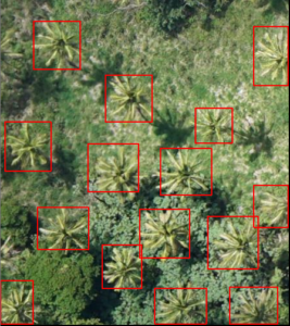
A training image chip with palm oil trees marked by rectangular bounding boxes.
The first step in an object detection workflow is gathering training data. In this case, it means manually collecting samples of palm trees that will be used to teach the deep learning algorithm what a palm tree looks like.
The collection is done by gathering image chips and digitizing bounding boxes around the palm trees present. Selecting trees that have different attributes (varying sizes, brighter or darker areas, somewhat obstructed trees, differing backgrounds, etc.) is important so the machine can learn all the possible characteristics to look for. Sometimes, users need to identify dozens or even hundreds of training chips to train a neural network. As the saying goes, “garbage in, garbage out,” so be sure to take time on this step to get the best results.
The collection of training samples is simplified in ERDAS IMAGINE. The user creates bounding boxes by using the mouse to drag out a rectangle around each oil palm to be used as a training sample.
Creating an initialized (trained) machine intellect
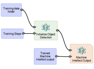
A spatial model for creating an initialized machine intellect to be used for detecting oil palm trees.
Next, the deep learning algorithm will study the training samples collected in the previous step.
In ERDAS IMAGINE, this is done using the Spatial Modeler environment, which has an operator named Initialize Object Detection that performs the training.
The training step creates an initialized (trained) machine intellect that will be used to detect palm trees in other images going forward. During this step, the initialized machine intellect will also be validated by an independent dataset to verify accuracy.
Detecting palm trees
The last step of the workflow is detecting palm trees in other images using the machine intellect created during the previous step. This is also done in the Spatial Modeler environment by constructing a model that takes the trained machine intellect and an input image, then automatically generates bounding boxes that define the location and number of palm trees in new images.
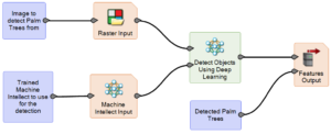
A spatial model for detecting oil palm trees.
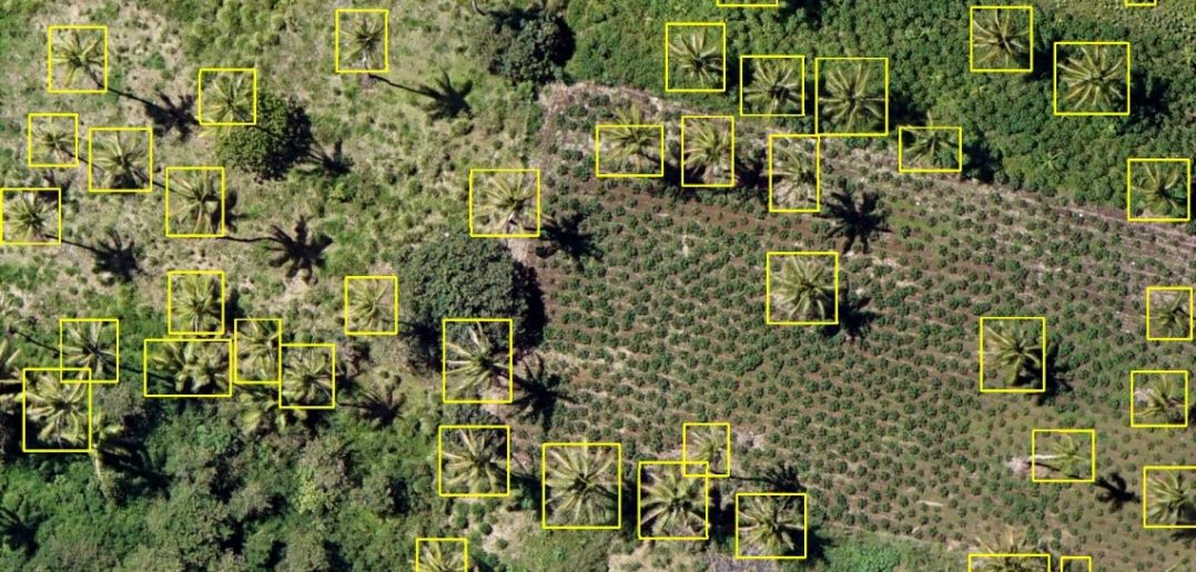
As you receive new aerial images containing oil palm trees, the model can be re-used to automatically identify, count, and perform analysis.
Going a step further, if you have images of the same location from two different time periods, the Change Detection features in ERDAS IMAGINE can be used to perform analysis to understand what is happening to specific plantations over time. Are more oil palms growing in that plantation than a year ago? Has the plantation been culled? Have more forests been cleared in the area to produce more palm oil? These are very sophisticated features that provide a lot of value to farmers and environmentalists alike.
You can see the entire process in action by watching ERDAS IMAGINE product owner Ian Anderson’s Tech Talk on the subject. Learn more about ERDAS IMAGINE and the Hexagon product family on our website.
