


The Hexagon Power Portfolio 2020 release improves collaboration, insights, and results for geospatial professionals. Important features have been added to Hexagon’s GeoMedia® solution, a flexible and dynamic GIS package for creating, updating, managing and analyzing your valuable geospatial information. Here are some of the features you can look forward to.
Excel Data Server Offers Limitless Tabular Data
This new data server provides access to tabular, nongraphic data stored in Excel spreadsheets (XLSX, XLS) and structured text files (CSV, TXT). Each text file is served as a warehouse connection with a single feature class, while each spreadsheet is served with feature classes for each sheet and each named range. The feature classes are read-only and have no primary key.
The Excel Data Server provides the same capabilities as the Attached Table option within the Access Data Server without limiting the amount to only 32,000 rows. Now customers with hundreds of thousands of rows can join their tabular data with their graphic data using this new data server inside GeoMedia.
Use the Explorer Window for Simplified Workflows
The TreeView now reflects any GeoWorkspace changes and is updated dynamically with added, removed, and renamed categories, categorized items, and queries, including retention of proper sort order. It also reflects all Connection changes and is updated dynamically with any change in warehouse connection name. Refresh All now refreshes tree contents while remaining expanded and retaining selected items.
An “Attached Data” branch is now introduced. Raster files that are dropped into the GeoWorkspace are presented here (for more information see the Drag-and-drop section below). The groups of images represented there may be added to a map window, or displayed in a data window, via the right-click context menu. More functionality for attached data will be provided in future releases.
New Drag-and-Drop Capabilities Improve Productivity
Drag-and-drop capabilities have been included in the GeoMedia 2020 release. Users can simply drag raster files and warehouse files from Windows File Explorer and drop them directly into their map window or the Explorer window.
Raster files are attached to the GeoWorkspace and appear under “Attached Data” in the Explorer window. They do not require a read-write warehouse connection. All raster file types supported by the Insert Georeferenced Images command are supported for drag-and-drop, and they are automatically georeferenced.
Warehouse files are made into warehouse connections and appear under “Warehouse Connections” in the Explorer window. The following file-based warehouse types are supported for drag-and-drop: GeoPackage, Access, File Geodatabase, Shapefile, GeoMedia SmartStore, KML, and Excel.
If dropped into the Explorer window, only the attachments/connections are made. If dropped into a map window, the data is additionally displayed. Of course, images can be dragged and dropped into the window as well. This feature gives the user more control and convenience, allowing them to choose which features they would like to populate the legend.
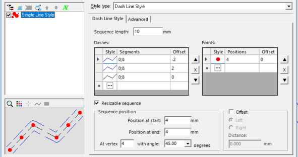
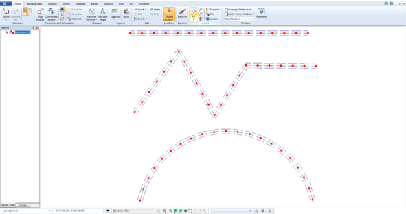
Styles and Rendering Keep Getting Better with New Dash Line Style
A new type of style definition for linear geometries is now provided that allows users to combine any number of dashes and any number of styles. This is a great new feature and alternative to the current Simple Line Style and Pattern Line Style. It allows for the definition of any number of dashes, and any number of symbols, each with their own position/length, styling, and offset from the geometry, and renders them in such a way as to keep them synchronized with one another. This overcomes a historic limitation with combining dashes (via Simple Line Style) and symbols (via Pattern Line Style) within a style collection, which allows the dashes and symbols to get out of synchronization with one another as they are rendered independently.
The new style type is presented on the Style Properties dialog as the Dash Line Style tab. The new style type also can be given attribute-based symbology or animation via its style properties located in the Advanced tab. Dash Line Style definitions may be imported and exported via the Styles command like any other style, may be copied between GeoWorkspaces and libraries, and behave like any other style type in the GeoMedia environment.
A Host of Other New Features
There are many other exciting features in the GeoMedia 2020 release, including better data sharing and access using 3rd party applications such as QGIS, more spatial operators including grid analytics, band chooser for multi-band images, support for geotagged photos and many more features that will further assist you to aggregate data – vector, image, raster, point cloud, and 3D – from a variety of sources into a single view.
You can read more about the GeoMedia 2020 launch in the release guide. GeoMedia is part of the Power Portfolio’s Producer Suite, which allows users to collect, process, and analyze geospatial data so they can produce meaningful insights. For more information on Hexagon products and services, please visit our website.
