Living in the city center of Brussels, I’m a frequent user of the Brussels public transportation network. With two trams and two busses stopping within walking distance of my place, I don’t really have an excuse not to take advantage of it. When I’m taking the metro, tram, or bus, I don’t need worry about finding a parking spot or being stuck in a traffic jam, and I can even read a book or write a blog post in the meantime.
Even if I weren’t using Brussels’ mass transit, I’d still benefit from it, as it helps reduce energy consumption and the production of greenhouse gases and other pollutants. On top of that, it frees up space — imagine just how much space 20 individual people traveling by car take up, compared to the same 20 people traveling on a single bus — decreases traffic congestion, makes city traffic significantly more pleasant for cyclists and pedestrians, and makes cityscapes more beautiful and peaceful.
If cities want to persuade even more private vehicle owners to use public transport, they need to meet commuters’ needs. Public transport service needs to be high quality for people to choose a bus or a train over their cars, and the quality of the service starts with the network.
Mass transit networks are complex. An error or delay in one segment can cause a ripple effect down the line — for the transport provider and the public. To manage this complexity, transportation agencies rely on different, disconnected data sources spread across multiple systems, departments, and formats. Typically, this data cannot be viewed in real time, making it difficult to gain a holistic view of the network’s asset conditions to coordinate maintenance activities or plan for new projects.
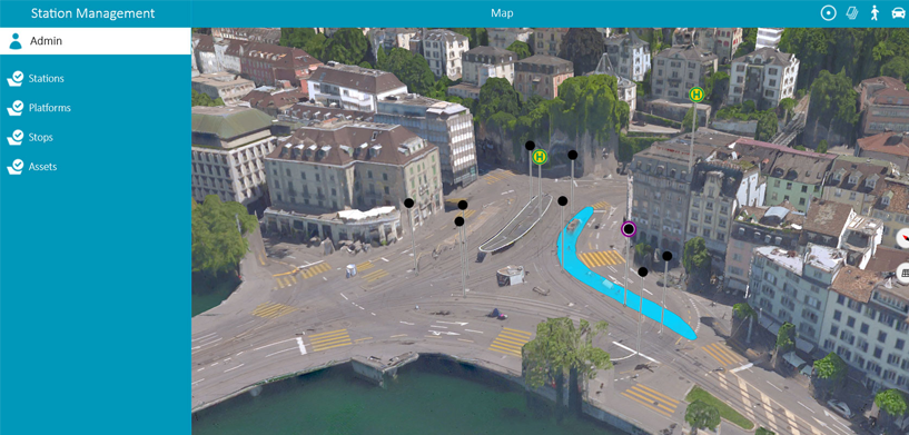
HxGN Mass Transit helps you manage your data, workflows, and transit networks more efficiently. It allows you to avoid data duplication by combining asset and spatial data into an integrated network, giving your team access to accurate and up-to-date information. With its 3D and AI capabilities, HxGN Mass Transit goes beyond a simple map to provide an advanced digital twin of a city’s entire public transportation network, from stops, tracks, and switches to construction sites, ticket machines, benches, and garbage cans.
With HxGN Mass Transit, public transportation operators can reliably plan and schedule asset maintenance, knowing that all necessary resources will be available when they’re needed — on schedule and on budget. Fieldworkers can get a precise visualization of all the network’s assets combined with predicted information as specific as where falling leaves will affect rail lines so they can execute their work in a safer, faster, and more targeted way. The organization will get more timely and actionable details on its maintenance budgets, and assets will be in the best possible condition, increasing efficiency and safety for workers, passengers, and the environment.
Citizens and commuters in the cities of Frankfurt (Germany) and Zürich (Switzerland) are already experiencing the benefits of HxGN Mass Transit’s mobile application as it’s being used to optimize field operations and better monitor assets. Frankfurt’s public transport operator, VGF, wanted to optimize its field operations and better monitor assets such as ticket machines, timetable displays, and garbage cans across its 5,000 stations and bus stops across Frankfurt. With HxGN Mass Transit, VGF can now easily inspect, validate, and share its infrastructure data because everything is automatically connected to a single source of truth and available on the fly.
If you want to learn more about HxGN Mass Transit, have a look at this on-demand webinar.


