


Land instability can have serious consequences. Landslides are not only damaging to the environment, but also dangerous to infrastructure and people. Falling rocks may destroy roads, pipes, and buildings and even kill bystanders.
Between the effects of human activity and climate change, land stability phenomena are occurring at a higher intensity and frequency than ever before, and monitoring and predicting instability has become too big a job for humans alone. An advanced technological solution is the best way to prevent injuries, deaths, economic devastation, and the destruction of property.
The mountainous parts of Italy’s Friuli Venezia Giulia region are especially susceptible to geohazards including landslides and sinkholes and are predisposed to slope instabilities and geologic weakness zones, such as fault zones, shear zones, and weak rock or mineral layers. The Geological Survey of the Autonomous Region of Friuli Venezia Giulia is responsible for monitoring these instabilities.
Continuous Data Collection and Analysis
To better observe and report on land instability, the organization commissioned Planetek Italia, a long-time Hexagon partner, to assist in developing a solution that would continuously collect, visualize, and analyze data on unstable areas. It also needed to monitor ground displacement affecting buildings and roads, both to protect citizens from danger and to prevent increased costs and delays to new developments.
The result, Planetek Italia’s Rheticus® Safeland solution, is powered by Hexagon’s M.App Enterprise, an on-premise platform for creating and deploying custom geospatial apps.
Safeland continually tracks ground movements via satellite radar interferometry. Satellite radar data is ideal for the task because it’s readily available, frequently updated, and allows users to identify trends in ground movement with millimeter-accuracy.
The organization is able to collect and provide detailed levels of information for buildings and transportation infrastructures, giving engineers, planners, and other users the ability to analyze ground movement phenomena over time with high precision. The complete picture provided by Rheticus Safeland gives support planners the vital knowledge they need to prioritize risk mitigation measures, make better decisions, and proactively avoid critical issues that arise when in-progress phenomena are not fully understood.
Easy to Use and Understand
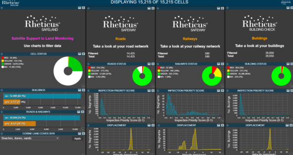
Even better, users do not need to have any knowledge of or expertise with satellite radar data, interferometry, or GIS applications. Interpreting this data typically requires considerable technical skill, and the results can be difficult for non-experts to understand. But Rheticus Safeland solved that problem by simplifying the complex information gleaned from radar data analysis. Its clear analytics and intuitive dashboard interface combine maps, reports, and dynamic geo-analytics in a single smart application that provides valuable insight.
Complex, multi-source data is automatically geoprocessed by the platform, so users can focus on what they do best: observing, tracking, and managing land to ensure the safety and security of people and assets. With Rheticus Safeland, these users get an accurate, comprehensive overview of their territory with timely updates and dynamic analytics. After implementation, the Geological Survey of the Autonomous Region of Friuli Venezia Giulia was able to significantly reduce the time and costs associated with traditional land imagery collection and ongoing software development.
Want to learn more? Download the complete case study.
