


Suppose you are part of your country’s census-taking team, which uses a modern, digital solution to gather census data — data which is critical for informing decisions such as how federal funding can be fairly distributed across initiatives and locations.
In preparation for conducting the census, a base map of the entire country is divided into administrative borders, and then it will be further subdivided into enumeration areas that are the territories covered by each enumerator, or interviewer. The map is sent to the entire census team – thousands of users – at once, by the map server.
As an enumerator, which of these two results showing the administrative borders of the country (in this case, around Cape Town in South Africa) would you want to see?
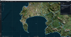
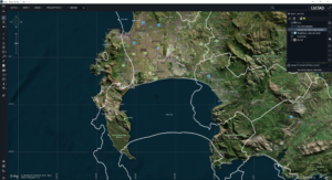
The first result was published by LuciadFusion, and the second result was published with an open-source server solution. Why do these two results look so different?
Support for Various Earth Projections
In the open-source solution, the server uses a spherical calculation (assuming the earth is a perfect sphere) where an ellipsoidal calculation is expected. An ellipsoid is much closer to the true form of the Earth, but these calculations are much more complex to implement.
If you are a geo-expert, you may know that the common Equidistant Cylindrical projection comes in two “flavors,” one with spherical calculations (EPSG:32662) and one with ellipsoidal calculations (EPSG:4087). LuciadFusion supports both flavors. The open-source solution officially supports both flavors as well, but in the case of EPSG:4087, it uses spherical calculations, rather than the expected ellipsoidal calculations, under the hood. This can lead to significant map shifts. In the above example, the results from the difference in calculations used can lead to a 20-kilometer error on the data in certain regions.
Taking a census is only one example of an application for a map server. Regardless of how you are using a map server, you may be surprised to learn how different server solutions can generate different results.
Geospatial servers have a big job; publishing massive amounts of geospatial data to up to hundreds of thousands of users at a time is not easy. Maps that start out as imagery – pictures of the Earth – can be transformed into GIS features that turn the pixels into roads, rivers, and so forth. Because most modern maps are updated frequently, servers are powerhouses, publishing current maps from even terabytes of imagery, to up to hundreds of thousands of users at a time.
Lessons Learned
For the best results (and maps), choose your map server solution carefully. Server solutions from Hexagon such as LuciadFusion can always be trusted to use the appropriate calculations that are required to publish the map features correctly. Our customers and partners have depended upon Luciad Portfolio technology for decades for real-time situational awareness across their entire organizations.
Want to learn more about LuciadFusion? Visit our website.
