


I was honored to present last week on behalf of Hexagon at the Monitoring and Evaluation for Climate – Smart Agriculture Workshop in Rome, Italy. The workshop was hosted by the Food and Agriculture Organization (FAO) of the United Nations.
During my presentation, I explained that the Agriculture sector is going to face enormous challenges to feed the 9.6 billion people that the FAO predicts will inhabit the planet by 2050. To meet this critical goal by that time, food production must increase by 70 percent.
In fact, this need must be met in spite of the pitfalls that affect agricultural production even today. The availability of arable lands has become increasingly limited. Moreover, procuring enough fresh water to sustain high-production rates will continue to be a problem, as agriculture consumes 70 percent of the world’s fresh water.
In addition to these known issues, other less predictable factors are also a concern. One such factor is the impact of climate change on food production. Shifts in seasonal events such as temperature and annual rainfall could lead to detrimental effects on the life cycle of plants and animals.
Smart Agriculture and its Role in Food Security
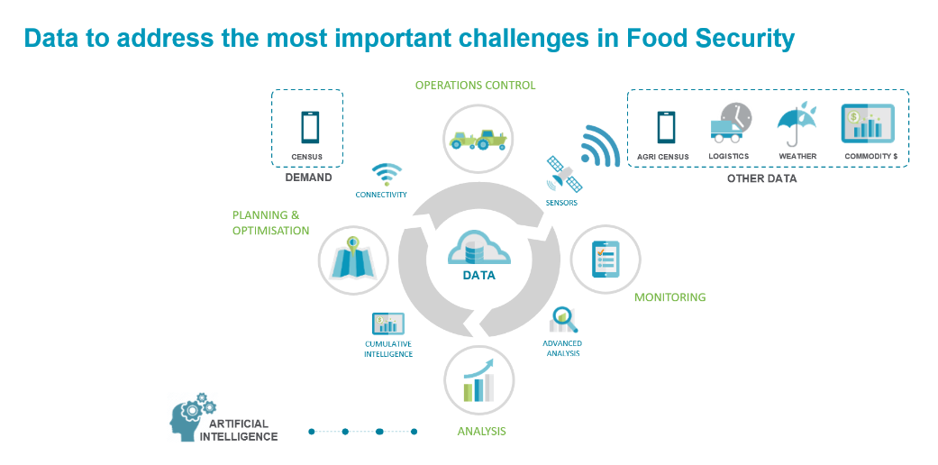
One way to address these issues and increase the quality and quantity of agricultural production is with precision agriculture, also known as Smart Agriculture or Smart Farming. Smart Farming is defined as a farming management concept that uses modern technology (such as GPS, soil scanning, data management, and IoT technology) to increase the quantity and quality of agricultural products. This technique makes farms more “intelligent,” connected, and productive.
On a similar note, remote sensing technology is improving rapidly. This is especially true considering the increased availability of satellite imagery at a lower cost than ever before. This development was confirmed by Benjamin Koetz from the European Space Agency (ESA), who presented ESA’s Sentinel satellite data acquisition and delivery program at the Smart Agriculture workshop.
Combining remote sensing technology with newly developed algorithms and data sources, such as sensor data, weather data, and population statistics, enables large-scale Smart Farming. The successful implementation of smart farming then leads to better monitoring and evaluation of food security interventions.
Determining Food Demand
The better we understand the extent and location of food demand, the better we can plan to address that demand. This is the case from both a commercial and small stakeholder farming perspective. To determine this demand, we can gather insight through census data analysis.
Census agencies around the world, such as those in South Africa and Botswana, are moving towards digital platforms for enumeration, or census interview gathering and completion. These digital platforms reduce the time between enumeration and access to results as well as reduce error and data loss. Similar techniques can be used for agricultural censuses to determine where food demand is highest.
Once the food demand is known, the supply can be planned. Every crop has a unique spectral signature as they reflect, absorb, transmit, and emit a different amount of electromagnetic energy from the sun. Many satellite-borne digital sensors have been developed to measure all types of electromagnetic energy. Thus, satellite data, in combination with remote sensing technology, makes it possible to identify crops on a large scale every five days by analyzing the spectral signatures. This technique can help us to define supply zones by assessing agricultural potential.
Tailoring Analytics to Understand Vegetation Needs
The next step is to monitor the crop yield and crop health. Fortunately, satellite data combined with ground sensors are accurate 75 to 95 percent of the time. Algorithms can calculate indicators like the Normalized difference Vegetation Index (NDVI), the Modified Soil Adjusted Vegetation Index (MSAVI2), the Green Normalized Difference Vegetation Index (GNDVI), and so forth.
These indicators, together with the visualization of additional data sources such as weather and fertilizer, can be integrated in a Hexagon Smart M.App, which can provide an interactive dashboard view for monitoring and optimizing crop yield. Another solution is to build and utilize visual analytics applications that integrate with enterprise resource planning (ERP) processes to manage stock and to interact with subcontractors.
Despite the serious challenges ahead, Smart Farming has the potential to seriously disrupt the current operation in the agricultural domain. We at Hexagon are excited to be leaders in implementing Smart Digital Realities for use in Smart Farming.
Learn more about the digital transformation already taking shape in the industry – which will play a major role in reaching global food security.
