


As the Multinational Geospatial Co-Production Program (MGCP) approaches its twentieth year, delegates from nations around the globe met in Mikulov in the Czech Republic for a technical group meeting, for which Hexagon was in attendance.
The purpose of MGCP is to collectively produce global vector data at 1:50,000 and 1:100,000 scale to a common standard. The features collected, their attribution, and how they are collected are decided upon by the MGCP technical group, with all nations having an opportunity to contribute to the guidance. With such a large task to create and then maintain the vector data, all nations are keen to share successful working practices and see production automated.
Geoprocessing capabilities
Hexagon has supplied software to defence and civilian users for many years, for the initial data orientation, feature collection, and cartographic production stages of the mapping flowline. Taking satellite imagery from different sources, orientating it to ground control, and then digitising or editing vector features and their attributions has always been a strength of Hexagon software.
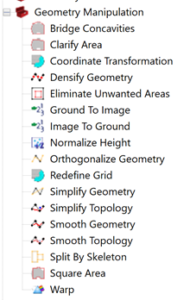
Recent updates to the popular GeoMedia GIS software have included the addition of relevant tools within the Spatial Modeler capability for “geoprocessing.” By using the 64-bit processing of Spatial Modeler, GeoMedia users can run prebuilt vector data modeling workflows or create their own. Relevant for MGCP and other cartographic production is the expanded range of Geometry Manipulation operators. These use the same enhanced cartographic capabilities that have been available in GeoMedia for many versions; they can now be used in a spatial model to automate workflows for high-quality map production.
With many mapping agencies producing different scale map products from one database of captured vector data, the step of generalisation is very important, but often time-consuming. Cartographic generalisation is when a smaller-scale map is derived from a larger-scale map or map data. The rules about which map features are merged, discarded, and moved, and how they are styled, are complicated. There must be balance between the map’s purpose and sufficient data being portrayed whilst maintaining representation of the real world.
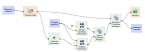
Building and using spatial models for cartographic production enhances productivity when collecting and validating vector feature data.
In the second part of this blog, we’ll look at other data workflows relevant to defence, such as photogrammetry and point clouds, that can be automated in Spatial Modeler with Hexagon software such as GeoMedia and ERDAS IMAGINE.
Read this complete white paper to learn more about future-roofing defence and civilian geospatial data workflows, visualisation, and management.
