


Hexagon Geospatial is invested in the future of the geospatial industry, and our education customers play a big role in our investment. That is why we continue to boost education initiatives offering students and professors partnership opportunities, programs, and grants for academic projects to expand learning. This year, we hosted a Geospatial Education Contest offering academia a chance to present their research using Hexagon Geospatial technology to business leaders at our annual conference, HxGN LIVE.
Although there could only be one winner, we had a special contest honorable mention that we would like to spotlight – Igor Sereda, an MSc student at Lomonosov Moscow State University. Igor’s research objective was to study remote sensing services for precision agriculture, a recent technology which is tackling the global food problem by introducing more efficient, environmentally-friendly approaches. He conducted his research in an experimental maize field near Novobeisugskaya village in Krasnodar region, one of the most productive agricultural areas in Russia.
For his research, Igor took into account a number of different data including hyperspectral sensors to identify specific wavelengths for assessing phytomass and water stress in plants, and field data (phytomass samples, field descriptions, ground spectra and factual yield) on selected fields. He also assessed the capabilities of Sentinel 2 MSI imagery and compared it with Gamaya OXI hyperspectral camera mounted on a UAV.
Igor used ERDAS IMAGINE 2016 Hyperspectral Analysis tools and Spatial Model Editor to assist with his research project.
Igor goes into more depth about his research below:
Both Sentinel-2 MSI multispectral satellite images and Gamaya OXI-40 hyperspectral UAV images have positive and negative sides for monitoring agricultural fields.
Images, obtained using UAV have higher spatial and spectral resolution, which makes it possible to distinguish the smallest changes of characteristics in a field (fig.1). However, the UAV image is an orthophoto which consists of many individual frames. Therefore, it could have darker or lighter areas which do not reflect the crop state but are caused by unstable lighting or by cloud shadows (fig.2).
Images of the Sentinel-2 MSI system most often cover the research area completely, so they do not have this problem. However, frequent cloudy weather limited their usability for agricultural monitoring in the region in 2016. Since 2017, with the launch of the second Sentinel 2 satellite, we can expect more useful data, especially for regional-scale monitoring.
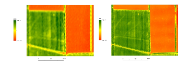
Fig.1. MSI (Moisture Stress Index) images of Sentinel-2 MSI (left) and Gamaya OXI-40 (right) systems.
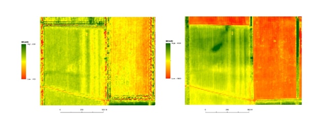
Fig.2. MCARI (Modified Chlorophyll Absorption Reflectance Index) images of Sentinel-2 MSI (left) and Gamaya OXI (right) systems.
Again, we would like to congratulate Igor on his hard work and for his innovation in the use of Hexagon Geospatial technology.
