


Change detection is a process that measures how the features of an area have changed over time. It often involves comparing aerial photographs and satellite imagery – materials used for land cover classification – taken from a specific area at different times. Change detection has been widely used to assess the effect that agriculture, mining, deforestation, and urban development have on the Earth’s surface.
The National Land Cover Database (NLCD) currently provides land cover classification data for the United States for the years 1992, 2001, 2003, 2006, 2008, 2011, 2013, and 2016. What happens when an analyst wants to perform change detection for years not found in the published works of the National Land Cover Database?
Tara McKinnon, a Geographic Information Science and Technology graduate student completing her master’s degree at the Georgia Institute of Technology, and who is also a research assistant at Tech’s Center for Spatial Planning Analytics and Visualization, is working to determine an answer to that question. She recently won an honorable mention in the EDU Program Call for Papers Contest and presented her work at HxGN Live Global 2019. Tara aims to create land cover classification for the state of Georgia that displays the change in land use that has accompanied population growth since 1970.
In those forty years, Georgia experienced an exponential boom as the population swiftly climbed from 4.7 million to 9.6 million people. As the state has accommodated and continues to welcome new inhabitants, the land use and land cover have changed and will continue to do so – especially in larger cities such as Atlanta.
Expanding the Amount of Available Land Cover Data
Tara began her project by looking for Landsat satellite imagery from the early 1970s, the early 1980s, and the present. ERDAS IMAGINE provides an analyst algorithm to generate change detection from satellite imagery over time, and this change data can in turn be used to produce useful information.
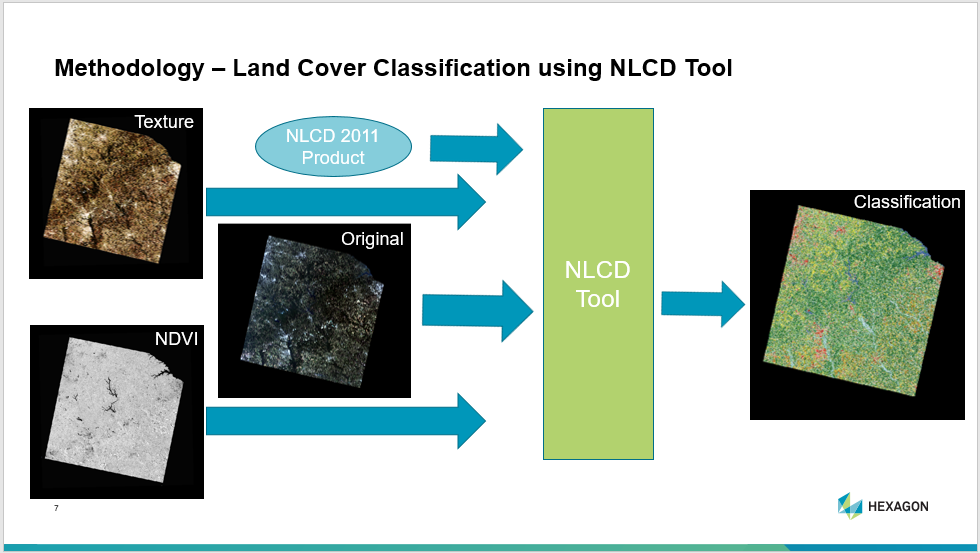
She plans to preprocess and mosaic the imagery in ERDAS IMAGINE and begin classification using the NLCD plugin. The NLCD plugin is a helpful tool built on the Spatial Modeler (a graphical interface used for building and running geoprocessing workflows). It uses a classification and regression tree (CART) machine learning algorithm to classify an image based on independent variables – the original image alongside derived imagery such as a normalized difference vegetation index (NDVI) – and a dependent variable, which in this case is an existing NLCD product for the area of interest.
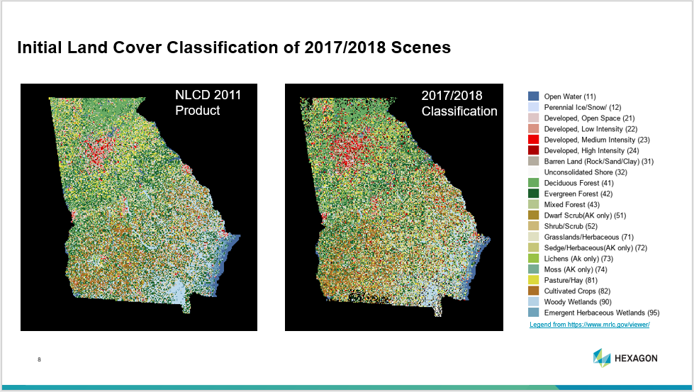
NDVI and texture will be run on the mosaicked images of Georgia, and the output will be entered into the NLCD tool using the 2011 NLCD product as the dependent variable. Results from this analysis will be entered into the See5 classifier tool to complete the classification. Once land cover classifications are complete for all three sets of dates, a series of change detection analyses will be conducted in ERDAS IMAGINE assessing how land cover has shifted from the 1970s to the present.
Tara will continue to repeat and refine her remote sensing analysis technique at Georgia Tech until the classifications are complete. See the video below for more information on her research.
To see more examples of our EDU students’ research, visit the Sensing Change Blog.
