


We go about our daily lives constantly surrounded by a multitude of sensors that collect a vast amount of information about all aspects of our surroundings. And ultimately, insights derived from this data have the potential to improve our surroundings and our well-being. However, while there’s no shortage of data about our cities or local authorities, town planners can rarely effectively leverage this information, mainly due to the complexity involved.
Through collaboration between Fujitsu and Hexagon, experts in sensor software and autonomous solutions, a solution is now available. It enables local authorities and planners to turn their data into insights quickly and easily. The Smart Monitoring Ecosystem (SME) solution brings together and visualizes multiple data streams and maps trends and patterns. SME adds the extra, valuable dimension of time to locally collected information to create spatiotemporal data for town planners.
An excellent example of how this works in practice is in public transport. Every city aims to make it as fast and easy as possible for its population to move around via various modes of transportation. The spatiotemporal data can add value for the users of public transport and all local citizens by reducing total journey times and minimizing the total amount of CO2 created. It does this by analyzing all journeys taken across different modes of transport in the context of time.
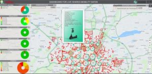
Munich has tested the use of SME in a completed pilot project to manage shared mobility. The SaaS solution makes it possible to track, visualize, and analyze IoT data from a variety of mobility providers and monitor shared vehicles, such as e-scooters, bicycles, and cars. It also features a dynamic digital twin of the city, a real-time digital representation of real and digital worlds. This allows planners to virtually test and optimize new processes before rolling them out.
The SME workflow is divided into three phases:
-
- To optimize the usage of shared vehicles, we start by visualizing all the available data using dashboards and maps. This allows us to identify the different types of vehicles available, including bicycles, e‑scooters, and car shares. We then add additional helpful information such as their current operational condition (for example, their state of charge) and how long they have been in their current location.
- Next, we continuously evaluate the data. This allows the user to identify spatial clusters (usage hot spots). In addition, by adding more layers of data (for example, by superimposing data from the local public transport network), the municipality can detect distinct behavioral patterns and visualize how frequently traffic routes are used.
- The third and final phase allows local authorities to draw conclusions from the information — and adjust their transport options to meet their targets more effectively, from sustainability to user satisfaction.
The SME solution also offers local authorities other convenient features. For example, the exponential growth of rental electric scooters and bicycles has created a new challenge: They are often abandoned with little consideration for fellow citizens, sometimes blocking sidewalks or pedestrian zones. SME offers an automated complaint management process that acts as an interface for citizens, administration, and shared mobility providers. This improves dialog with residents and reduces the administrative burden of dealing with these issues and complaints by optimizing resources.
SME: How it works
SME brings together various components, including IT infrastructure, GIS, operation, maintenance, support, and consulting. This makes it easy to deploy at short notice, as initial output can be generated in just 48 hours, providing a solid basis for further analysis or as the starting point for a proof of concept.
Deployment is easy for local administrations as there is no need for complex software installations. Users access the powerful software via a web browser or an app and simply select which data to record, taking into account any issues of digital data ownership.
Guaranteed data security
We’ve recently seen an uptick in the number of cyber attacks on public administrations, underscoring the importance of robust data security. The SME solution is based on an integrated blockchain that guarantees both data security and authenticity, ensuring that insights are derived from accurate data input.
Ultimately, to improve any local service, it’s essential to understand it in detail, and SME makes it possible for planners to do just that. But cities change over time, so this data analysis isn’t a single event — SME is designed to deliver ongoing evaluation. That means it is ideally suited to form part of continuous improvement cycles of “measure, plan, act,” allowing town planners and authorities to keep pace with the speed of change and ultimately ensure better services and enhanced well-being for their residents.
