


With the exponential growth of the number of images (and radar data, and point clouds, and…) that are being collected, we must answer this question: how are we going to make sense of all of this data? And even before making sense of it, how are we going to sift through the amount of data to a manageable heap? How do we tell what needs further attention and what can be archived for later?
The answer seems to be “Give it to the machines and let them sort it out.” Now that might seem a little harsh, but it really makes sense. With the amazing technological advancements in machine and deep learning, we can upload a photo to Instagram and within minutes, search engines can serve it up as “cats in pajamas” or “dogs wearing hats.” (Personally, I much prefer the dog photos, but my coworkers assure me that cats remain very popular in internet searches.)
So how can we harness the power of the image processing to perform more commercial and administrative tasks? How can we ingest the massive amounts of geospatial imagery collected every day and winnow it down to just the mission-critical data that needs to be interpreted by specialists?
The answer is by creating spatial models that utilize Machine and Deep Learning to perform the heavy lifting.
What is Machine Learning and how does it differ from Deep Learning?
Let’s back up a little bit here and start with Artificial Intelligence. This technology enables machines to perceive their environment and learn to adapt to the changes occurring there. This has been around since the 1950s.
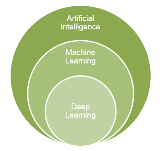
Machine Learning is a subset of Artificial Intelligence, which first began getting traction in the 1980s. This method uses statistical methods to enable machines to improve their performance without being explicitly programmed. One aspect of Machine Learning – Bayesian Networks – has been used for years by Hexagon Geospatial’s premier data authoring software, ERDAS IMAGINE, to extract features such as roads, buildings, and aircraft from images (GIS data).
Deep Learning is in turn a subset of Machine Learning. This method trains and adapts itself using Deep Neural Networks (DNNs) to process large amounts of data. This is a much more intensive process than Machine Learning, as shown below.
Machine Learning: Building on the Familiar
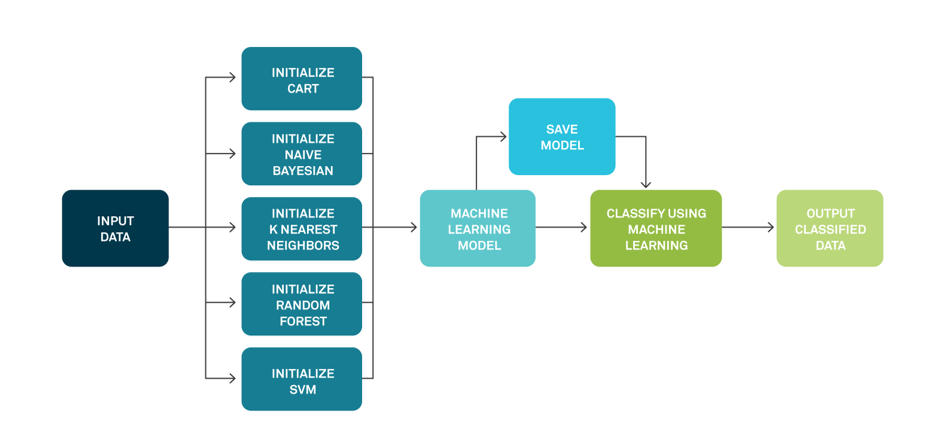
Machine Learning, as we said, has been used in ERDAS IMAGINE for years. Taking a satellite image and using K Means or ISODATA algorithms to group the pixels of the input image into landcover categories or classes was one of the first applications of machine learning. And tools like IMAGINE Objective made use of Bayesian networks to take imagery, classify it, and then extract features like rooftops and aircraft. More recently, algorithms such as Classification and Regression Trees (CART), Support Vector Machines (SVM) and Random Forests, have been added.
Remote Sensing specialists, who build landcover categorization models, can look at a Machine Learning workflow for image classification and feel comfortable with the process.
Read more about using Machine Learning with geospatial data.
Deep Learning: Deep Neural Networks
Deep Learning is a little more complicated. Instead of a simple, linear workflow, the model processes all of the training images in a series of steps or “hidden layers.” For a typical geospatial data workflow like landcover classification, a Convolutional Neural Network can be designed that will process the imagery in a number of “layers” or steps. In a typical classification network, you would have Convolution layers, Pooling Layers, Activation Layers, Flattening Layers, and Densifying layers. Each of these layers contain a specific type of computation or analysis step and can vary based on the data or the complexity of the process
Dig further into the details of Deep Learning for geospatial applications.
Machine and Deep Learning in ERDAS IMAGINE
For years, ERDAS IMAGINE has provided the Spatial Modeler, a graphical tool for creating models to perform remote sensing and GIS processing tasks in a repeatable, scalable way. Today, ERDAS IMAGINE includes a number of Machine Learning and Deep Learning operators that allow you to build, train, run, and deploy these new and powerful techniques. We have made it easier for you to take technology that was developed to identify cats in social media posts and use it to define landcover categories – or other mission-critical tasks, like change detection.
Explore More about Machine Learning and Deep Learning
For more information on how you can use the ERDAS IMAGINE Spatial Modeler to perform remote sensing tasks, please read the Understanding and Using Machine Learning and Deep Learning Operators white paper.
