


Water is vital to every living thing on the planet, and the Netherlands has more than 2,200 square miles where the land meets water. Most of that land is man-made, and there is hardly a single part of the Netherlands left where you can’t see human intervention. The battle against flooding waters has played a major role in the design of the landscape. Without man-made adjustments like windmills, dikes, and water barriers, half of the Netherlands would not only be uninhabitable, but also underwater.
Because of this, strategic water management is instrumental to the nation, and various organizations have been entrusted with water management responsibilities. Drinking water companies produce and supply the country’s drinking water, municipalities are responsible for the sewer system, the Rijkswaterstaat governing body manages large bodies of water, provinces manage groundwater, and waterboards manage water regionally and treat wastewater.
Dutch waterboards, like Waterschap Drents Overijsselse Delta (or WDO Delta), are regional water authorities that are democratically elected and charged with managing water related issues in the Netherlands. To stave off flooding and make the country habitable, waterboards manage and maintain many dikes, locks, pumping stations, flood barriers, canals, and ditches.
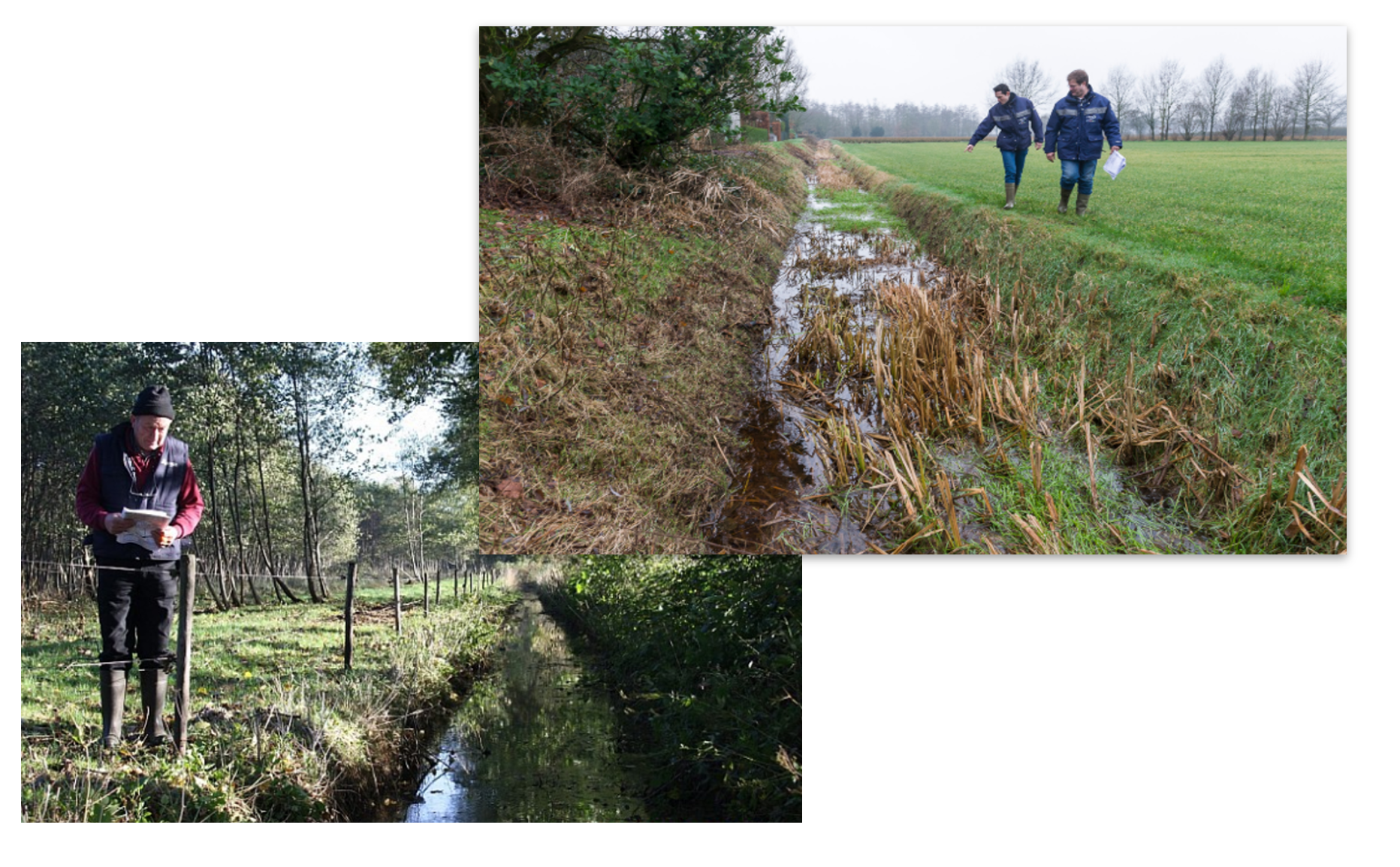
WDO Delta employs approximately 500 people, including field inspectors, a General Board, Executive Board, and a Dike Reeve, or a chaired officer who is charged with complete oversight of the dikes and drains in the country. As one could imagine, it is an arduous task for the boards to manage the large number of field inspectors needed to examine miles of waterways to rapidly identify any problematic areas. Inspectors often walk for miles while maintaining organized and detailed information regarding their findings. Handwritten data collected in the field can be easily lost or illegible, especially when working in heavy rain and strong winds.
Automating Regulation of Over 4,300 miles of Water Passages with Hexagon Technology
Each year in autumn, about 60 WDO Delta employees spend an entire week checking for obstructions in water flow. The blockages in waterways are usually formed by vegetation or other pollutants. This task normally requires more than one iteration, including an initial check and a follow-up for complex situations. The process is painstakingly laborious and time-intensive and hampers staff availability for other activities.
Members of WDO Delta wondered if it was possible to automate the evaluation process, easily collect and transfer the data, and ultimately limit the amount of field work required. Enter Hexagon’s Geospatial division and our longtime partner IMAGEM. With our full set of Geospatial products and solutions, we set out to help WDO Delta accomplish all of their streamlining initiatives.
ERDAS IMAGINE provided all the advanced remote sensing models needed to monitor the water network quickly and accurately. Spatial models customized by IMAGEM recognized the phenomenon of waterway obstructions in aerial photographs by analyzing data with samples. Then, with machine learning and intelligence models, obstructions requiring service from field inspectors were quickly detected in specific water network segments.
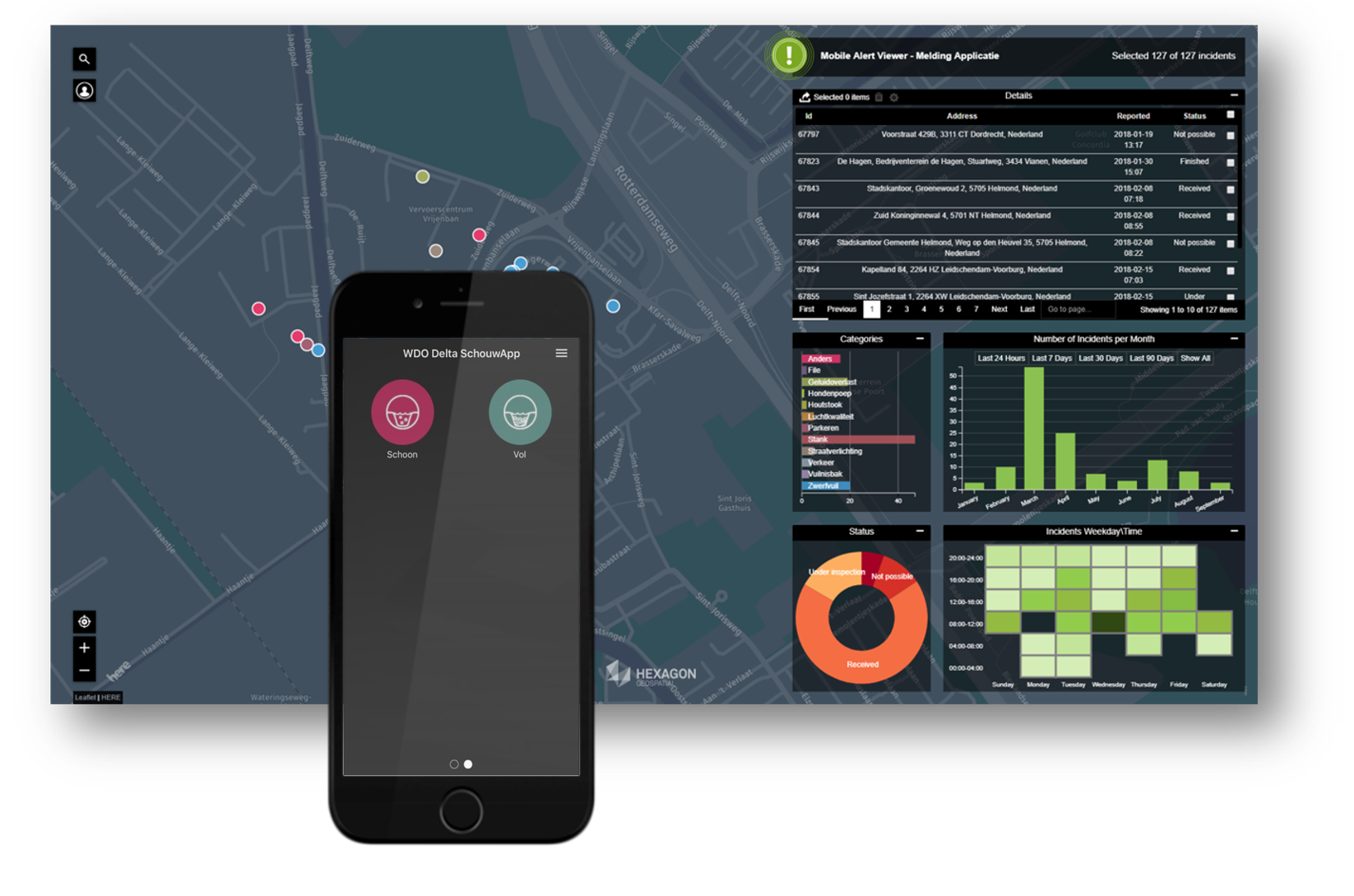
Field inspectors also used Mobile Alert, a crowdsourcing tool for collecting georeferenced incident reports and images, to examine only a fragment of the water network and gather the data ERDAS IMAGINE required for machine learning. Then, Mobile Alert was also used going forward to collect data easily during infrastructure inspection right from the inspector’s mobile device.
While on location, issues were noted using Mobile Alert and assigned to the appropriate category, e.g., a full channel. Optionally, photos were taken of each issue. The coordinates of the issue were saved automatically, and the data was sent to the server. This meant that any required field inspections were also used as new input for machine learning.
Using Geospatial Portal (a web app for sharing enterprise geospatial data and web services) and Mobile Alert Viewer (the administration portion of mobile alert), managers could monitor the network condition and inspectors’ work progress. The consumer portal created with Geospatial Portal also allowed for providing information to the required authorities or to the public.
A 50% Increase in Accuracy with Smarter Network Management
Using the previous traditional methods of imagery comparison, WDO Delta could identify approximately 40% of blockages accurately. Using Hexagon’s products, IMAGEM’s models, and machine learning, where the model was trained to identify specific situations, WDO Delta achieved a recognition rate of 90% in just a few months.
“We have been partnering with IMAGEM for many years now,” said Jeroen Waanders, Information Advisor at WDO Delta. “They think along with us in finding solutions that generate added value for us. This project affirms that technological developments really do offer possibilities to support organisational goals in an innovative way.”
WDO Delta pioneered a breakthrough approach to regulating their water systems by simply eliminating the need for relentless site visits. Their staff will no longer be required to check each waterway physically for blockages that hamper waterflow. Rather, the ‘smart’ solution will identify areas that require field inspection.
WDO Delta’s next goal, with support from IMAGEM, is to attain a self-regulating water system – the first of its kind in the Netherlands.
To learn more about ERDAS IMAGINE, Mobile Alert, or any other Hexagon products, please visit our website, where you can also learn more about our partner IMAGEM.
