


To analyze city data most effectively for governance and sustainability, city officials would probably agree that a location intelligence tool should meet these requirements:
- City departments need to work from the same enterprise-level data source as a single source of truth. For example, historical and real-time data, and maps as well as business data, need to be accurate, secure, and available to all departments.
- Departments can have their own requirements for how they want to analyze the data to solve their own challenges. The questions that one department asks of the data may vary considerably from those of other departments because they are focused on solving very different problems for the city.
The most effective data analysis tool meets both these requirements. The US City of Baton Rouge, Louisiana, had requests from two of their departments: 1) Finance and 2) Mayor-President’s Office/District Attorney, to find the best location intelligence tool that would let them connect to the city data to answer their specific questions.
Finance Department
Many city governments are largely funded by revenue from local property, sales, and other taxes. Tax-exempt businesses affect the amount of revenue the city collects.
Before using location data, it was difficult for the Finance Department to show where and how much money the council districts were losing from tax-exempt revenues. They wanted to accurately answer council district questions about the amount of funds in each district that were being lost due to tax exemption.
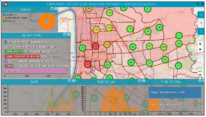
Mayor-President’s Office
Dilapidated or unsightly properties affect the value of the surrounding properties, which in turn affects the owners of those surrounding properties. Neglected or abandoned properties can attract criminal elements and are also often structurally unsafe, posing risk to anyone who might happen onto them either intentionally or by accident.
Working with the District Attorney, the Mayor-President’s Office wanted to extract from their service calls the locations of blighted properties. To request service for a neighborhood problem like unkempt property, graffiti, or potholes, their citizens can call the 311 non-emergency phone number. The city wanted to better track the 311 calls that specifically related to blighted properties. According to these officials, dealing with blighted properties is a step toward reducing crime and thereby improving quality of life.
Solution: Apps with Map-centric Dashboards
The City of Baton Rouge implemented a Hexagon Geospatial enterprise solution called M.App Enterprise to build and privately host map-centric dashboard apps that require no GIS or programming experience to configure. These apps allow departments to view the data plotted on a map, along with simultaneous chart and graph views that answer their specific location intelligence questions, all within one solution.
Warren Kron, GIS Manager at the Department of Information Services at the City of Baton Rouge, has advice for officials in other cities who want to help their city become a smart city: “Talk to Hexagon, provide a sample of your data, and see a demo,” said Kron. Before your departments create their own apps, each department should, “think thoroughly about the questions you want your dashboard to answer,” because that will determine what type of charts will best display the results of your data analytics in the form that you want to see.
To see how M.App Enterprise is helping to make cities smarter, read A Smarter City, the Baton Rouge case study.
