


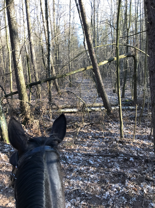
Imagine you are an experienced equestrian taking a leisurely ride on a local horse trail. On the trail, you come across a place where a storm has left broken tree limbs in your path. You are faced with a decision: are you (and your horse) experienced enough to safely attempt to cross the roadblock, or even venture off the trail? Should you turn around?
How do you tell anyone visiting the trail tomorrow about this hazard?
Often, scenarios like these are unexpected and require immediate decision making. Attempting to cross dangerous hurdles can pose a safety risk for both equestrians and their horses.
One university student has developed a solution that not only allows equestrians to see obstacles on horse trails before they start their journey, but also lets them report any trail hazards they encounter without even leaving the saddle.
Reporting Obstacles on the Trail
Victoria Zamojska, a student earning her degree in Geoinformation at the University of Lodz, designed a solution to increase safety for local equestrians on the Lodz Horse Trail in Poland.
As part of her master thesis, she developed a Mobile Alert Smart M.App called Horse Trail, which collects crowdsourced data regarding hazards on the trail.
“The main objective of the project was to improve safety and comfort during horse trips for equestrians,” said Zamojska. “There was a need to store data regarding trail hazards in one location.”
During her research, Victoria discovered the valuable benefit of using a crowdsourcing platform to gather data on trail hazards, their locations, and the specific types of problems they caused. Having this data stored centrally adds to the convenience of the solution.
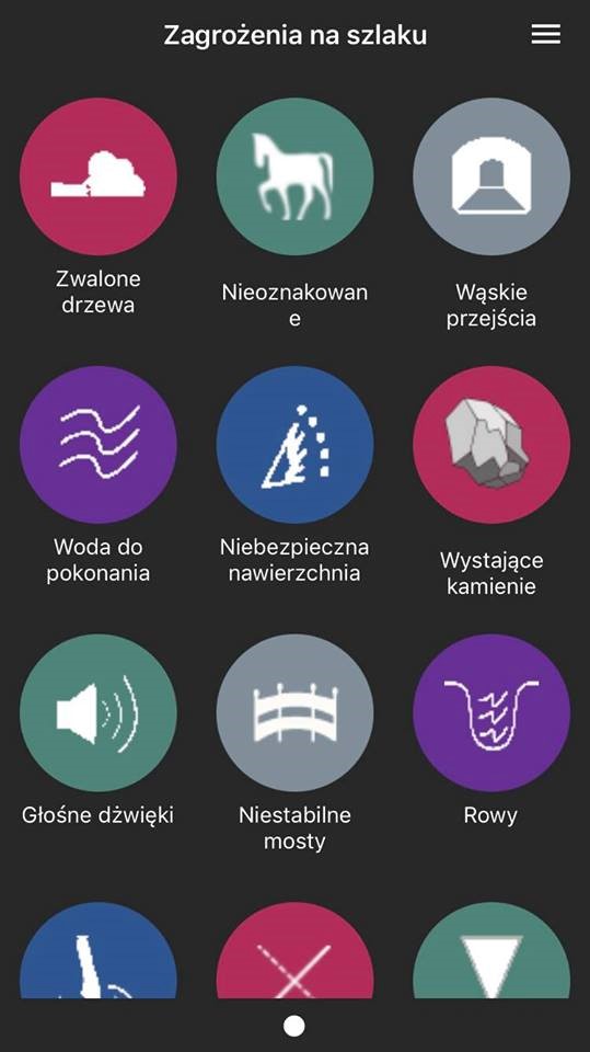
To report an issue, equestrians on the trail can use the free Mobile Alert reporting application from either Apple’s App Store or the Google Play Store. All they need to do is take a photo of a hazard and add any other relevant details before submitting the report.
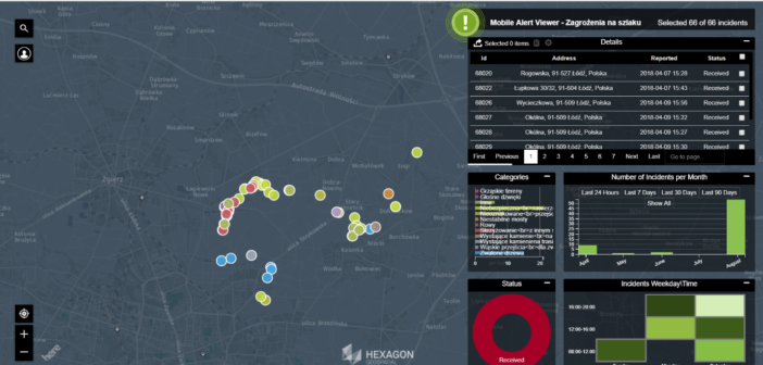
As part of the Horse Trail Mobile Alert Smart M.App, each report is immediately viewable in an interactive map dashboard that shows all reported hazards from the trail.
The data from the Smart M.App can also be used by trail managers and maintenance crews to keep the trails safe and accessible. Since each report’s photo is georeferenced, those in charge of upkeep know exactly where each hazard is located.
The photos also help maintenance crews see the extent of the damage, which allows them to prioritize needed repairs. Seeing the hazard beforehand ensures maintenance can bring the right tools with them to fix the issue as well.
As an active equestrian, Zamojska is especially interested in the safety of the Lodz Horse Trail. After developing the Horse Trail Mobile Alert Smart M.App, she introduced her work to some of the City Guards in Lodz in the hopes that she can encourage them to make the Smart M.App part of the safety, upkeep, and maintenance procedures for the trail.
Mobile Alert: The Technology Behind the Solution
When Zamojska began her thesis project, she first had to decide on the technology to use to turn her vision into a reality. For her, choosing the Mobile Alert crowdsourcing platform was simple.
“The main reason for me to choose this Hexagon Geospatial product was due to the clear and user-friendly interface, wide spectrum of possible applications, and easy navigation through different options of the product,” she said.
After deciding on Mobile Alert, her project was divided into five milestones:
- Inventorying the Horse Trail: First, Zamojska created a base map to document the state of the trail prior to any incidents, which she used to help develop the Smart M.App.
- Configuring the Horse Trail Mobile Alert Smart M.App: To design the solution, Zamojska used the Mobile Alert Configurator Smart M.App, which lets the app creator define areas of interest in the monitoring location, reporting categories, and other settings for their Smart M.App.
- Sharing the Free Mobile Alert Reporting App: Next, she requested that members of the local equestrian society download the free app from an app store. Members from two local stables downloaded the Mobile Alert reporting app.
- Testing the Horse Trail Mobile Alert Smart M.App: After downloading, the members of the equestrian team put the reporting app to use by sending reports of any issues they encountered on the Lodz Horse Trail – either during rides or while visiting the trail as pedestrians.
- Conclusion and Results Display: Finally, Zamojska was able to see all of the crowdsourced reports from the equestrian society as emails, as well as through the interactive dashboard view provided by the Mobile Alert Viewer Smart M.App.
Zamojska has successfully completed these project milestones and has finished the technical aspect of her entire thesis. In addition to developing a project that increases public safety for her and the rest of the equestrian society, another win she notes from her project is that “University of Lodz has now acquired a new tool (Mobile Alert) which can be used to analyze data.”
She now hopes to expand the scope of the project beyond what has been accomplished as part of her university work. Zamojska aspires to share all of the crowdsourced data with the equestrian society in the form of a new data portal, so everyone can access the reports and make informed trips to the trail.
Zamojska also hopes to expand the use of the Horse Trail Mobile Alert Smart M.App to other trails so that more equestrians can safely navigate them with their horses.
Want to learn more about Mobile Alert? See how another Mobile Alert Smart M.App is ready to help eradicate dangerous hogweed plants plaguing rural citizens around the globe.
