How do you manage a forest when the data you have doesn’t relate to trees?
Hexagon Geospatial India – Professional Services works with forest agencies to answer this question and overcome more challenges to develop solutions specifically focused on managing forests and woodlands.
First, the team sits down with several forest agencies, one at a time.
The team reviews all of the agency’s data and its sources. Typically, numerous datasets are already available to forest departments. They get data from the forest agencies, or from vendors, or directly from the field. However, it’s not feasible to directly publish that data and begin using it. It doesn’t work like that.
Whatever data is being used by the department, the data must first be modeled in a unified data model, a common data model that caters to the various workflows of the forest departments that share common data structures. We engage with each agency to understand its domain. Together we try to arrive upon a unified data model, then develop a unified data model ideal for that particular department.
On top of the unified data model, Hexagon geospatial technologies provide services including web processing, user management, MIS integrations, and weather systems, to name a few. These technologies in Geospatial Portal, M.App Enterprise, ERDAS APOLLO, ERDAS IMAGINE, and GeoMedia are the foundation for building custom modules. We talk to each department about which modules best suit their needs, then these modules can be presented in browser-based apps, mobile apps, desktop apps, 3D globe, or 5D tablet.
When we work with forestry solutions, we categorize them into modules:
- Data Authoring – such as forest type, mapping
- Forest Monitoring – such as plantation monitoring, forest fire monitoring, wildlife monitoring
- Forest Planning – such as site suitability for plantations, planning for plantations and nurseries
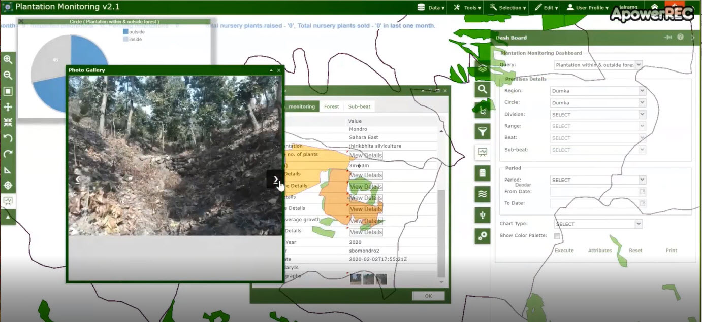
- Forest Analytics – typically dashboards are always looked at in isolation, but we can combine dashboards and analytics
Building a customized geoportal for Jharkhand Forest Agency is just one example of our team’s work.
Jharkhand Forest Agency Geoportal
Situated in eastern India, forests and woodlands cover about 30% of the state of Jharkhand, whose name means “area of land covered with forests.” Jharkhand Forest Department is entrusted with all matters pertaining to forests and forestry, including protecting and conserving the state’s forest and wildlife resources through scientific forest management practices.
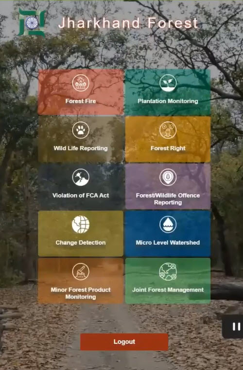
When a desktop or web user logs in to the Jharkhand Forest portal, the user has access to numerous modules, including:
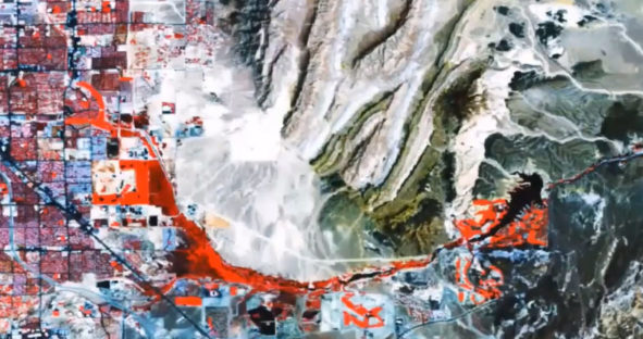
- Forest Fire alert Analysis and Burnt Area Identification — Daily notification of forest fires, analysis of cause, and extent of burn area
- Citizen Forest Incident Reporting — Citizens near a forest can report incidents like poaching, forest fires, or illegal logging
- Micro Level Watershed Extraction — Provides web-based watershed analysis for officers looking for suitable plantation sites
- Plantation Monitoring — Monitors various plantation activities, including period monitoring by change detection
- Minor Forest Product Monitoring — Economically important forest products such as herbs, fruits, and tree bark are monitored, and the inventories and locations are managed in a centralized repository
- Wildlife Reporting — Monitors wildlife by citing locations, monitoring damage, field reporting via apps, migration reporting, and analyzing the migration with historical data
A mobile application is available too for Forest Guards, who are the field staff. They have various modules accessible to them, based upon their credentials. They can update data directly from the field using customized forms connected to the desktop application. The mobile app works in tandem with the respective module in the geoportal.
One of our big challenges was getting forest agency staff to adopt and use the implemented solutions, as well as training the thousands of forest guards and persuading them to put the new solutions to use. For one customer, we trained nearly 2,500 staff, creating a WhatsApp group for quick posting of issues. In addition, top-level officials gave clear instructions mandating use of the application for daily reporting purposes, which also helped the ground-level staff to adopt and adapt quickly.
Forestry Module Solutions in Action
Watch our webinar by Dwaipayan Dighal and Ashish Arora to learn more and see examples of these modules in action:
- Forest Fire Monitoring
- Forest Burn Index Ratio built with spatial models
- Live feed of a thermal camera mounted on UAV providing video of actual fires
- Site Suitability for Planation Planning
- Wildlife Reporting
- Nursery Management