


It’s time to get real. We’ve been able to create 3D representations of GIS data for quite a while now. What I want to discuss is another step in the progression to a 3D environment that, although based in earth science, is approaching virtual reality – all within the context of a Geographic Information System.
The focus of my attention is Environmental Effects. These effects can be used to create a truly immersive environment for projects. This can be particularly important when your project needs to gain the approval of a special interest group or has to stand public review. Once you move a GIS project out of the realm of the technical experts, the focus changes from the exacting specifications, analytics, and problem resolution to more general aspects and aesthetics. Beyond the justifying the investment of the a project, is the emotional justification. The general public or vested interest groups want to know about the social impact that the project will have on its surroundings. That is a challenging aspect of complex projects and one that you don’t want to overlook.
GeoMedia 3D can be a valuable tool in addressing this challenge. How so? By including even more reality into the representation of the project. For example, you can introduce sun, shadows, and clouds into the GIS environment. The time of day can be set to create views for early morning, afternoon, and as night falls, all adding to a better understanding of the finished project. Weather conditions can be added and varied, adding to the realism. You may be wondering what this has to do with a comprehensive GIS analysis, especially if you’re adhering strictly to the analytical aspect of the project. You still have to address the emotional and social aspect. Once you take this into account, there are benefits that can be derived from environmental effects.
You can engage your target audience by navigating around the area to show off the aspects of the 3D representation of the project. The more realistic you make it, the more convincing your model will be. There’s no better way to help visualize a project, especially if it will be a dramatic change. A lot of time is spent building the GIS environment that underlies a project. You can augment it with 3D content from a content provider using the import 3D object utility in GeoMedia 3D. The 3D models in the image below were provided courtesy of Pictometry Corporation. The shadows are courtesy of GeoMedia 3D.
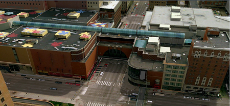
Figure 1. GeoMedia 3D with Dynamic Shadow Adjustment
One last thought—As you start to utilize environmental effects, you are introducing changing conditions over time. Once you bring time into the equation you’re now using your GIS in 4 dimensions!
Resources:
GeoMedia 3D Effects Demonstration
GeoMedia 3D More Effects Demonstration
