


With the rise of Daesh (also known as ISIS or ISIL) and other extremist organizations in the Middle East and North African region, there has been an increasing number of cultural crimes committed. The current security climate makes it virtually impossible to keep an eye on many of these irreplaceable cultural heritage sites, but that is where the power of remote sensing takes over. To provide an updated graphical representation of cultural crimes committed by these groups, the Antiquities Coalition partnered with Hexagon Geospatial to create the Culture Under Threat Map.
The Antiquities Coalition’s Culture Under Threat Hexagon Smart M.App lets users crowdsource eyewitness images of the incident.
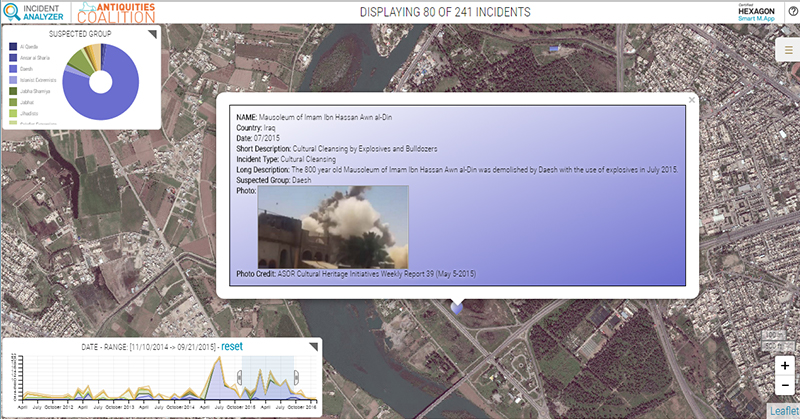
Remote sensing has always been used to monitor inaccessible areas, but the Antiquities Coalition took this technology to the next level by creating a dynamic Hexagon Smart M.App. The Culture Under Threat Smart M.App is an ideal use of the ground-breaking technology, combining current high-resolution satellite imagery provided by Digital Globe with Smart M.App technology. The ability to view different data combinations, including a simple slider for viewing only events within a specific timeframe, has already provided unique insights into cultural cleansing that were not previously available through standard, static GIS maps.
Viewing this timeline with any combination of data sets allows for a unique examination of temporal patterns. This allows experts to not only quantify data across a wide region, but provides an opportunity to understand the types of patterns that are occurring, which can better inform them in the development of solutions to the critical threats caused by cultural cleansing.
The map is being released as part of the #CultureUnderThreat Task Force Report, which is the first comprehensive set of recommendations by respected NGOs to the U.S. government to combat cultural racketeering and cultural cleansing. This report details the current situation in the Middle East and North Africa and puts forward a series of recommendations for the U.S. government, international community, and art market that address the core issues – cultural crimes that are closely linked to security threats, money laundering, transnational organized crime and international terrorist financing.
Sites and data regarding the destruction or damage to a site can be crowd sourced and when pictures are taken at damaged historical sites, the images can be uploaded to the Smart M.App so the map becomes an active information management exchange and information visualization tool.
About Culture Under Threat M.App
- The Antiquities Coalition’s interactive map only includes museums and sites designated by the United Nations Educational, Scientific, and Cultural Organization (UNESCO) whose information is publicly available so as not to reveal to Daesh the details of other critical but lesser known locations of cultural, historical, and religious history.
- The destruction in the countries examined has revealed more than 230 sites that have been deliberately targeted or destroyed by Daesh and other violent extremist organizations. Destroyed heritage includes significant monuments from the ancient, Greco-Roman, Islamic, and modern periods alike.
- The Culture Under Threat Map currently shows nearly 700 heritage sites throughout the 22 states of the Arab League — 209 UNESCO World Heritage and Tentative List Sites (34 of which are in Iraq and Syria), 230 damaged or destroyed sites, and 277 museums.
- The Hexagon Smart M.App is a dynamic, cloud-based platform that uses high resolution imagery and maps paired with multiple fluid streams of real-time information. This information can be dissected, analyzed and visualized to deliver a picture of what is happening in the moment over a specific location. More importantly, Smart M.Apps help develop analysis that can be used to forecast future possibilities and outcomes based on current and past trends.
